


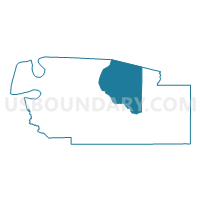
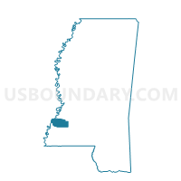
Red Lick Voting District, Jefferson County, Mississippi
About
Outline

Summary
| Unique Area Identifier | 605801 |
| Name | Red Lick Voting District |
| County | Jefferson County |
| State | Mississippi |
| Area (square miles) | 67.72 |
| Land Area (square miles) | 67.68 |
| Water Area (square miles) | 0.04 |
| % of Land Area | 99.93 |
| % of Water Area | 0.07 |
| Latitude of the Internal Point | 31.78615660 |
| Longtitude of the Internal Point | -90.95733150 |
Maps

Graphs
Select a template below for downloading or customizing gragh for Red Lick Voting District, Jefferson County, Mississippi


Neighbors
Neighoring Voting District (by Name) Neighboring Voting District on the Map
- District 1B, Claiborne County, MS
- District 5A, Claiborne County, MS
- District 5B, Claiborne County, MS
- Ebenezer Voting District, Jefferson County, MS
- Fayette Manor Voting District, Jefferson County, MS
- Lorman Voting District, Jefferson County, MS
- Union Church Voting District, Jefferson County, MS
Top 10 Neighboring County Subdivision (by Population) Neighboring County Subdivision on the Map
- District 3, Jefferson County, MS (4,912)
- District 1, Claiborne County, MS (2,631)
- District 5, Claiborne County, MS (1,806)
- District 2, Jefferson County, MS (971)
- District 1, Jefferson County, MS (605)
- District 5, Jefferson County, MS (507)